A Global Navigation Satellite System (GNSS) is a constellation of satellites providing signals from space that transmit positioning and timing data to GNSS receivers. These receivers then use this data to determine their location. European GNSS (E-GNSS) consists of the satellite signals sent by the Galileo constellation and the augmentation services provided by EGNOS. One of the responsibilities of the European Union Agency for the Space Programme (EUSPA) is the management of the European GNSS system. It does this through the GNSS Service Centre (GSC), which supports service provision and provides a single interface for Galileo users. EGNOS operation and service provision has been contracted by the EUSPA to the European Satellite Services Provider (ESSP), enabling also a single interface for EGNOS users via this EGNOS User Support website.
EGNOS
The European Geostationary Navigation Overlay Service (EGNOS) is Europe's regional satellite-based augmentation system (SBAS) that is used to improve the performance of global navigation satellite systems (GNSSs), such as GPS and Galileo. EGNOS provides three services: Open Service, Safety of Life and EGNOS Data Access Service (EDAS).
EGNOS uses GNSS measurements taken by accurately located reference stations deployed across Europe. All measured GNSS errors are transferred to a central computing centre, where differential corrections and integrity messages are calculated. These calculations are then broadcast over the covered area using geostationary satellites that serve as an augmentation, or overlay, to the original GNSS message.
As a result, EGNOS improves the accuracy and reliability of GNSS positioning information, while also providing a crucial integrity message regarding the continuity and availability of a signal. In addition, EGNOS also transmits an extremely accurate universal time signal.
For more information, click here.
Galileo
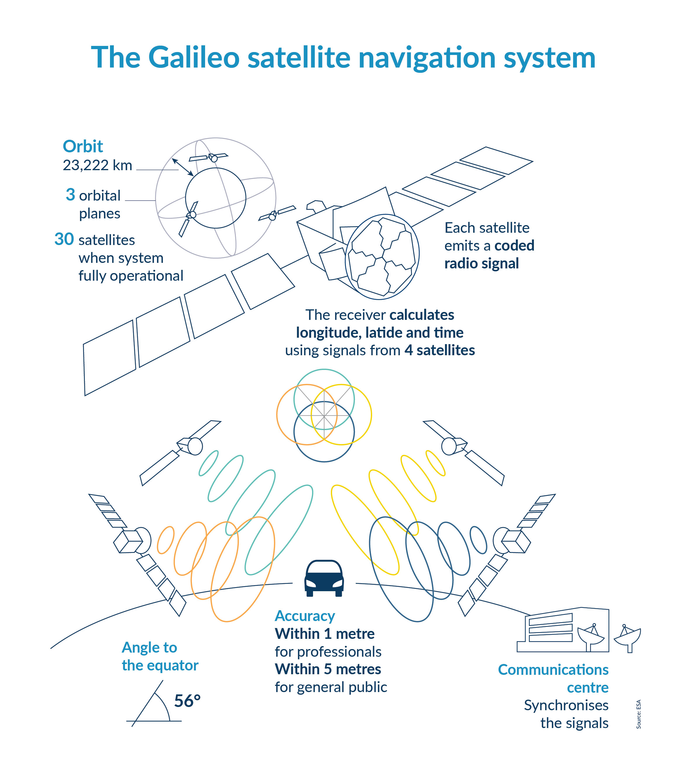
Galileo is Europe’s Global Navigation Satellite System, providing standalone navigation, positioning and timing information to users worldwide. Unlike other systems, it is under civilian control and has been designed in response to the diverse needs of different user communities. The four Galileo services (Open Service, Commercial Service, Search and Rescue and Public Regulated Service) will offer various levels of accuracy, robustness, authentication and security. Galileo declared its provision of Initial Services in late 2016.
Galileo provides benefits for European services and users, such as:
- It allows users to know their exact position with greater precision than other available systems.
- The products that people use every day, from the navigation device in their cars to their mobile phones, benefit from the increased accuracy that Galileo provides.
- Critical, emergency response-services benefit from Galileo.
- Galileo’s services will make Europe’s roads and railways safer and more efficient.
- It boosts European innovation, contributing to the creation of new products and services, creating jobs and allowing Europe to own a greater share of the EUR 175 billion global GNSS market (Source: GSA Market Report Issue V).
For more formation, click here.